 |
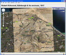
Georeferenced mapsA series of Edinburgh maps from the NLS collection, primarily from the 19th century but also including some 18th and 20th century maps, have been georeferenced. For a list of Edinburgh maps georeferenced so far visit: For a full list of georeferenced on the NLS site visit:
|
 |
Chronological map of EdinburghJ.G. Bartholomew's chronological map of Edinburgh (1919) illustrates the urban expansion of Edibnburgh at 10 points in time. From our georeferenced version vector layers were traced enabling us to create 2 and 3 dimentional representations of the map (with and without timelines). You can download each of the KML (Google Earth) variants or view them online (requires Google Earth plugin).
|
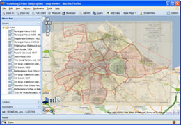 |
ExtMap viewerExtMap is an open source framework based on the ExtJS JavaScript library and Google Maps API originally developed by Alper Dinçer. Building on this framework we have developed a viewer to bring together maps from the NLS collection and some useful research tools. Features include: add your own maps and data; Google Street View; bulk geocoding; integration of the Topocoding API. It is also possible to set up your own instance of our ExtMap viewer using Google Spreadsheets to store your configuration details. Customisable options include: map start point, map layers; bookmarks. More detailed information on the customisable viewer will follow soon. In the meantime if you are interested please contact us. |
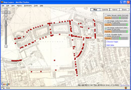 |
Map and Google Spreadsheets data mashupThis is an early version of our map viewer which illustrates how georeferenced maps can be combined with point data from an online data feed. In this instance Google Spreadsheet is used to store geocoded information about tenement plaques in the Marchmont area of Edinburgh. Users can select the map layers they would like to view and then link to the point data which is read in as an RSS feed from a published Google Spreadsheet. Note that it is possible to add your own geocoded data by added data to your own Google Spreadsheet and obtaining the spreadsheet ID. If you are interested in doing this and would like more information please contact us. |
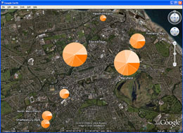 |
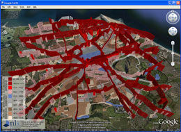
Edinburgh Cooperative Building Company (ECBC)The Edinburgh 'colonies' are well known locally as a distinctive form of housing, being terraced, low density and only of two storeys compared to the typical, 4 storey 19th century Scottish tenements of between 6 and 16 flats. The colonies were built by building tradesmen, who formed a limited liability company, between 1862 and 1930. This example illustrates colony populations in 1891 as proportional symbols formed by pie charts indicating occupational structure.
Note this thematic mapping technique for visualising statistics in Google Earth is based on the open source Thematic Mapping Engine developed by Bjřrn Sandvik. |