Browse maps

Scroll the panel below to view the maps

This viewer allows you to explore a selection of historic maps of Stornoway and environs, dating between 1785-1964. The core of the collection is seven manuscript maps from Stornoway Public Library, supplemented by several printed and manuscript maps from the National Library of Scotland. Also included are maps by Ordnance Survey and an Admiralty/Hydrographic Office chart.

The maps provide many insights into the development of Stornoway over the last two centuries, including proposals (some not implemented) for its development. Also included are maps of the Lews Castle Estate (1850), proposals for the Pentland Railway (1890), and a pioneering vegetation survey of Lewis and Harris (1919).

1785 - Stornoway harbour bay and town

Plan of the harbour bay and town of Stornoway, 1785

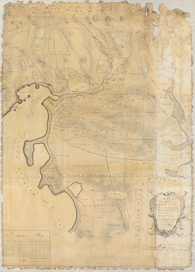
This beautiful and striking estate plan, commissioned by and dedicated to Francis Mackenzie, 1st Baron Seaforth, is the earliest detailed record of named proprietors in Stornoway, and is therefore of major value for local and family history. As is customary for estate maps such as this, each land parcel has been carefully measured (written out in Acres, Rods, and Falls) and its broad agricultural use or potential has been described. The distinction into Arable, Pasture, Moor & Sand, and Moss are the main categories, but more detailed descriptions too. The map deliberately gives no detail of the main built-up part of Stornoway itself; Chapman’s map of 1800 (see below) provides the complementary detail here.

  • Title: A Plan of the harbour bay and town of Stornoway. With the adjoining lands. Part of the island of Lewis. Belonging heritably to Francis Humberston Mackenzie Esq. Seaforth. Made out of an accurate survey taken anno 1785.
  • Date: 1785
  • Description: 1 map: col.; 160 x 100 cm.
  • Courtesy of Stornoway Public Library

ca. 1800 - Stornoway

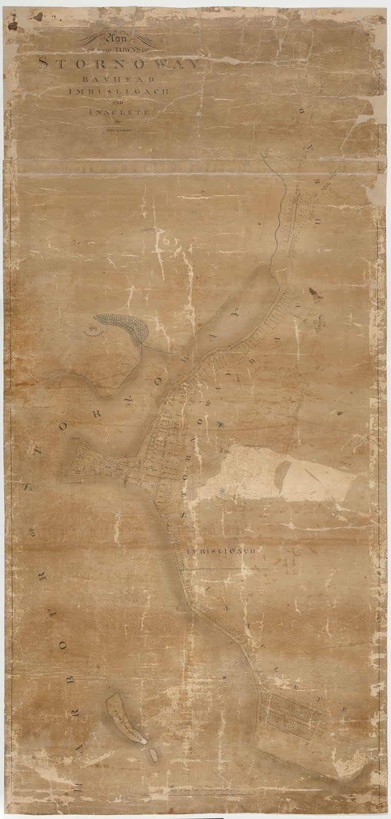
James Chapman, Plan of the Town of Stornoway, 1800

Francis Mackenzie, 1st Baron Seaforth, appointed James Chapman as Chamberlain between the late 1790s and about 1810. Chapman also worked as an estate surveyor on Uig in Skye in about 1803, and, later, practised as a land surveyor in Inverness, in partnership with Alexander Gibbs. Chapman oversaw the creation of thirty-four crofts on the island of Bernera (north-west Lewis) by 1807, probably the earliest crofts created in the Outer Hebrides. He was one of the main promoters of sheep in Lewis, managing major sheep runs in the north-west of the island to the east of Little Loch Roag, as well as the island of Pabbay, and on Valtos to the north.

This is the earliest surviving detailed map of the town of Stornoway, and related settlements of Imrisligach and Inaclete. The central streets are named, and buildings are clearly shown. Each numbered plot of land has been carefully measured in acres, rods and falls. Inaclete (towards the lower edge of the map) has been carefully laid out in a grid plan with three parallel streets; there is no evidence that this was constructed.

The conservation of this map in 2018 is described in this blog post.

  • Name: Chapman, James
  • Title: Plan of the Town of Stornoway, Imrisligach and Inaclete
  • Date: ca. 1800
  • Description: 1 map: col.; 140 x 70 cm.
  • Courtesy of Stornoway Public Library

1821 - Stornoway

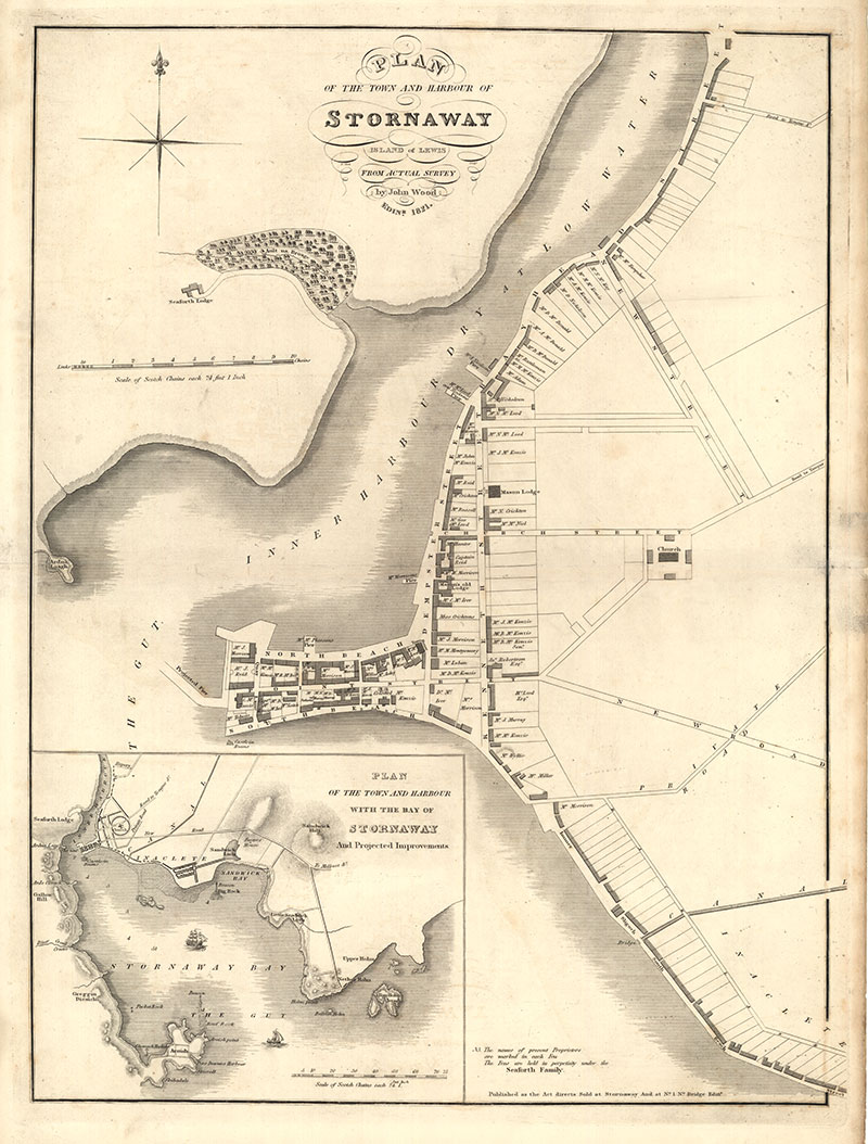
John Wood, Plan of the Town and Harbour of Stornaway, 1821

John Wood (c.1780–1847) was the most significant surveyor of British towns in the early nineteenth century. Between 1818 and 1846, he drew maps of at least 148 towns in Britain – a monumental achievement given the difficulties of travel and a relatively small market for urban maps. In a few cases, Wood borrowed from the work of earlier map makers, and these borrowings are clearly credited, but he more often undertook original survey, as is certainly the case for Stornoway.

John Wood’s printed plan is particularly valuable for its list of the main property owners in Stornoway itself, several of whom had had illustrious careers overseas. Captain John Mackenzie (who lived at the corner of South Beach and Quay Lane) had distinguished himself at the defence of Gibraltar against the combined forces of Spain and France (1779–1783), and died in 1830 aged 67. Further east along South Beach we can see Carn House, the property of Colonel Colin McKenzie, who died in May 1821 in Chowringhee near Calcutta, the year this map was published. Mackenzie left Stornoway/Steòrnabhagh for Madras in 1783, and, in 1815, was appointed Surveyor General of India, headquartered at Fort William in Calcutta. It is possible that the £30,000 which Mackenzie left his sister in Stornoway/ Steòrnabhagh, which she used to support numerous charitable causes, funded the work by Wood. Further east again, at a building marked ‘McLeod Esq’ (today the site of Martin’s Memorial Church), was the birthplace of Alexander Mackenzie, the Canadian explorer, remembered for his pioneering traverse across the Rockies to establish a landward route across Canada.

The National Library of Scotland also holds a manuscript plan of Stornoway, dating from this time, with several planned (and unrealised) developments, including an elaborate circus around the Church (today St Columba's Old Parish Church). This is sketched in the small inset “...Bay of Stornoway” map with projected improvements. Although never built, the idea was kept alive in later years: Leverhulme’s plans for a new canning factory in the town in 1918 used Wood’s design as a model.

Wood settled in Edinburgh from 1813, and his initial work focused on Scottish towns; 48 of these were gathered together into his Town Atlas of Scotland (1828), together with a detailed Descriptive Account of the Principal Towns in Scotland (1828), with its useful description of places, including Stornoway:

"Stornoway was, within the last twenty years, only a small fishing Village, but from the spirited and patriotic exertions of Lord Seaforth, the proprietor, and the grant of irredeemable feus for building, it has become a place of considerable importance as a Fishing station. No place in the north of Scotland, and in an insulated situation, also, has made more rapid strides at improvement, both in a domestic and commercial point of view, than Stornaway. The fisheries, especially for white fish, is conducted on a large scale. The number of boats fitted out annually for that fishery, amount on average to 120."
  • Name: Wood, John, ca. 1780-1847
  • Title: Plan of the Town and Harbour of Stornaway, Island of Lewis, from actual survey.
  • Date: 1821.
  • Description: 1 map ; 761 x 548 mm.
  • Courtesy of the National Library of Scotland

1846 - Stornoway

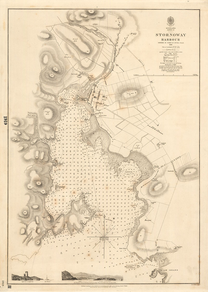
Hydrographic Office, Stornoway Harbour, 1846

This is the earliest detailed Admiralty chart of Stornoway Harbour, surveyed by Commander Henry C. Otter in 1846. As well as showing soundings in feet, marine hazards and anchorages, it also shows the general condition of the sea bed (g. gravel; m. mud; r. rock; s. sand; sh. shells; st. stones). The safe passage into the harbour is clearly shown with sketches at the base of the chart of the lighthouse on Arnish Point, and the transit from Coul Island to Lews Castle.

As Otter wrote in a later 1874 pilot guide: ‘The land in the vicinity of the east side of the harbour of Stornoway is comparatively low, and many accidents occurred before the erection of the lighthouse [in 1852] in consequence of vessels mistaking one or other of the small bays for the entrance to the harbour. In hazy weather, the Barvas range may probably be first made out, when it [the ship in question] should be brought to bear N.N.W., and kept on that bearing until the entrance is seen. In coming from the north, take care to bring the lighthouse in sight by day, and the light by night, before rounding Chicken Head, so as to clear the Hen and Chickens’.

  • Name: Great Britain. Hydrographic Office
  • Title: Stornoway Harbour
  • Date: Surveyed 1846, published 1849.
  • Description: 1 map ; 677 x 501 mm.
  • Courtesy of the National Library of Scotland

1849 - Stornoway

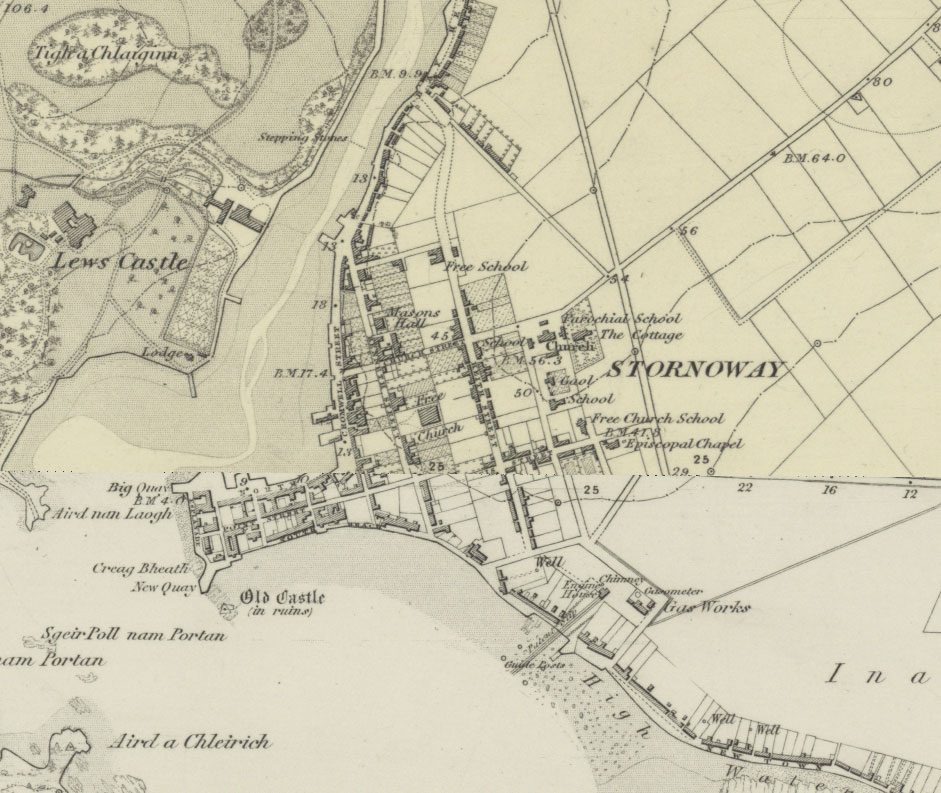
Ordnance Survey six-inch to the mile, 1849

Ordnance Survey were persuaded by the Proprietor of Lewis, James Matheson to map the island out of turn in 1849-53. Whilst this had the advantage that Lewis was mapped before virtually all of the Scottish Highlands and Islands, it had the disadvantage that the basic scale of mapping at this time was only six-inches to the mile (1:10,560). From 1855, the basic scale became 25 inches to the mile, but Lewis was not mapped at this scale until the second edition / first revision of the mapping in the 1890s.

  • Name: Ordnance Survey
  • Title: A georeferenced layer of County Series 25 inch to the mile mapping
  • Date: Revised: 1895-97
  • Description: Each map ; 64.4 x 96.6 cm.
  • Courtesy of the National Library of Scotland

1850 - Stornoway

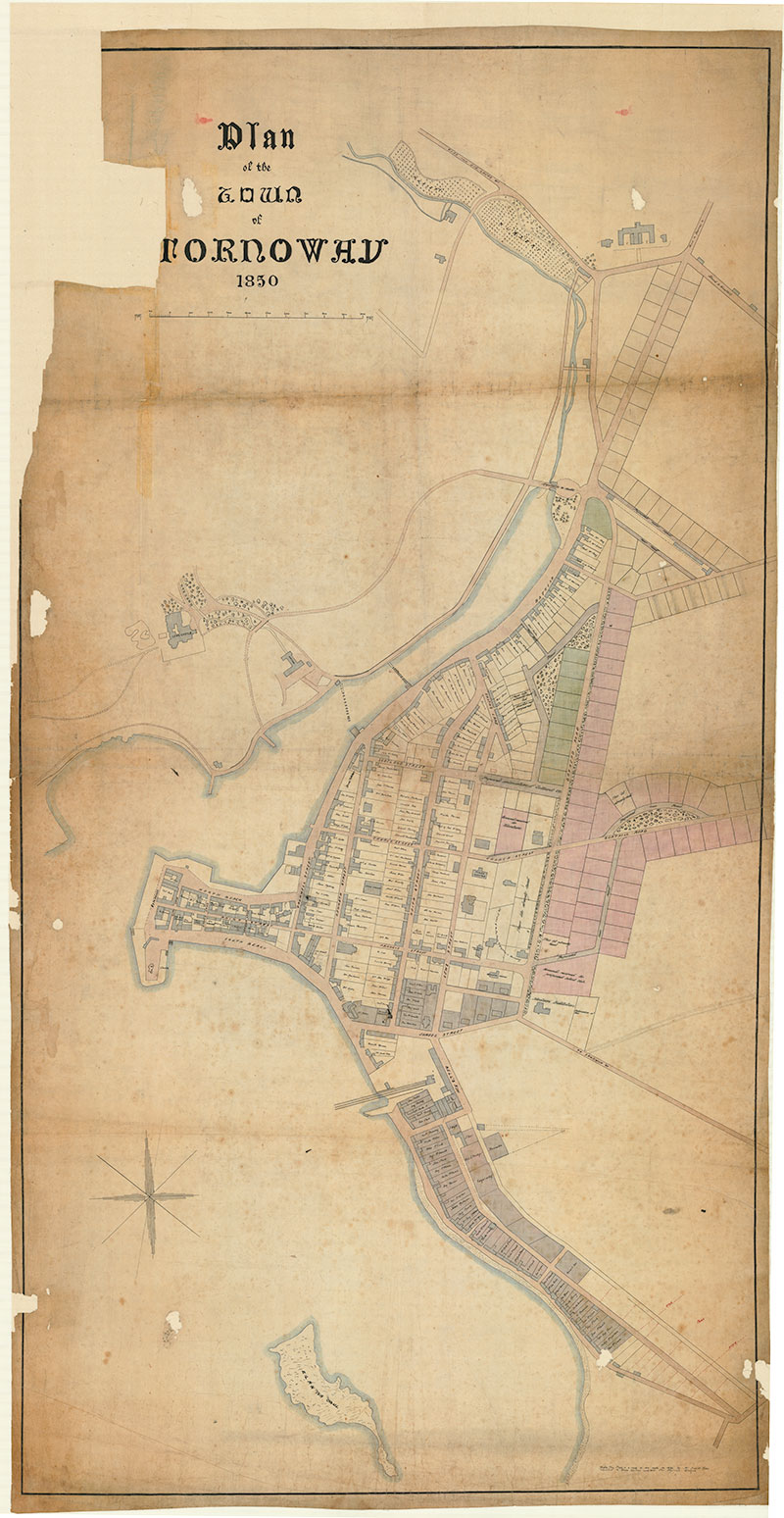
Plan of the town of Stornoway, 1850

This manuscript map of Stornoway is extremely useful as a detailed, cadastral plan (ie. showing land ownership), naming all the proprietors of houses in Stornoway and Inaclete in 1850. It is drawn at a very large scale of 1:1200, allowing each individual building and plot of land to be clearly shown. The map could perhaps have been commissioned by the Town Council for planning purposes, and in addition to showing the planning of feus and grounds, it clearly has been used to plan new developments. These include new streets and buildings to the east of the town, such as the continuation of Scotland Street, and roads to join with Bayhead Road / Matheson Road. The map shows the Nicholson Institute (1870s) in the right location and a proposed road which became Goathill Crescent (at the end of the 19th century). That said, many of these proposed developments, which are mostly coloured in red and green, were not implemented. A note at the bottom of the map reads ‘This plan is a copy of one made in 1840 by Mr David Miller, assistant to Messrs Gordon and Will, Civil Engineers, Glasgow’, who were presumably commissioned to survey the original map for the Town Council.

  • Title: Plan of the town of Stornoway, 1850
  • Date: 1850
  • Description: 1 map: col.; 100 x 193 cm.
  • Courtesy of Stornoway Public Library


1850 - Lewis Demesne

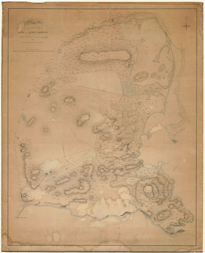
Plan of the Lewis Demesne / drawn by William Ogburn, Ordnance Survey 1850

Following his acquisition of the Island of Lewis in 1844, James Matheson commissioned the architect, Charles Wilson, to build his new residence, Lews Castle, on the site of the former Mackenzie's Seaforth Lodge. The major construction project began in 1847, accompanied by remodelling of the grounds, and was completed in 1870 at a cost of around £40,000.

The uneven and rugged grounds around the castle were remodelled as an ornamental and estate landscape, with a variety of woods and open grounds, and with superb elevated views over Stornoway and beyond to the sea. As the map clearly shows, carriage drives and an extensive network of paths provide access through and around the grounds, creating numerous circuits and providing a variety of vantage points. Whilst the creation of the new Lewis Demesne involved the clearance of tenants, confiscation of former arable and grazing ground, and re-routing of public roads, the unpopularity was tempered by Matheson’s provision of employment, famine relief and various other projects for the benefit of the community at the time.

This manuscript map is by William Ogburn of Ordnance Survey, a rare instance of Ordnance Survey staff working on a private commission, to map the 'Lewis Demesne' or estate grounds. The map is at a very detailed scale of 2.5 feet to the mile or 1:2,112 - larger than the Ordnance Survey’s 25 inch to the mile scale, which would be adopted from 1855. The map is interesting in largely reflecting symbols and features shown on the Ordnance Survey large-scale town plans, then being actively worked on in Scotland, including the use of hachures to reflect basic relief, embankments and cuttings, and showing spot heights in feet above mean sea level.

This map bears useful comparison with the Ordnance Survey six-inch to the mile map, surveyed in 1849. This 1850 map, surveyed in the following year, shows several new features, and as it is at a much larger-scale, allows better detail to be shown. For example, the ornamental pond to the west of the castle with its island is shown more clearly, there are new buildings to the north of this pond, a new sunken garden feature further west, and extensive cottage garden / shrubbery area to the north.

  • Name: Ogburn, William
  • Title: Plan of the Lewis Demesne / drawn by William Ogburn, Ordnance Survey 1850
  • Date: 1850
  • Description: 1 map: col.; 99 x 123 cm.
  • Courtesy of Stornoway Public Library


1893 - Topographical map of proposed Pentland railway

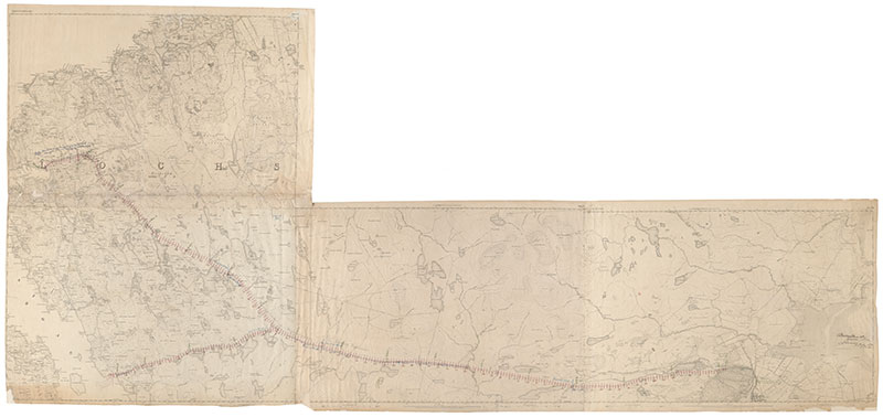
Topographical map of proposed Pentland railway

This proposed railway, dating from the 1890s, was planned to connect Carloway and Breasclete on the west coast with Stornoway. Work began on the scheme, but ran into economic and legal problems. Although the railway was never constructed, the ‘Pentland Road’, largely followed the same route, and was built instead by 1912. The road was named after John Sinclair, better known as Lord Pentland who was the Secretary for Scotland between 1905 and 1912 and who helped to secure funding for the completion of the road.

This map is made up for four original Ordnance Survey first edition six-inch to the mile maps from the 1850s that have been stuck together, with the route itself annotated on top. It accompanies the vertical section of the route, shown above. Near Carloway, there is an additional "Blue line shewing route originally surveyed Changed to avoid damaging arable land."

  • Title: Topographical map of proposed Pentland railway
  • Date: 1893
  • Description: 1 map; 130 x 276 cm.
  • Courtesy of Stornoway Public Library

1895-97 - Ordnance Survey 25 inch to the mile

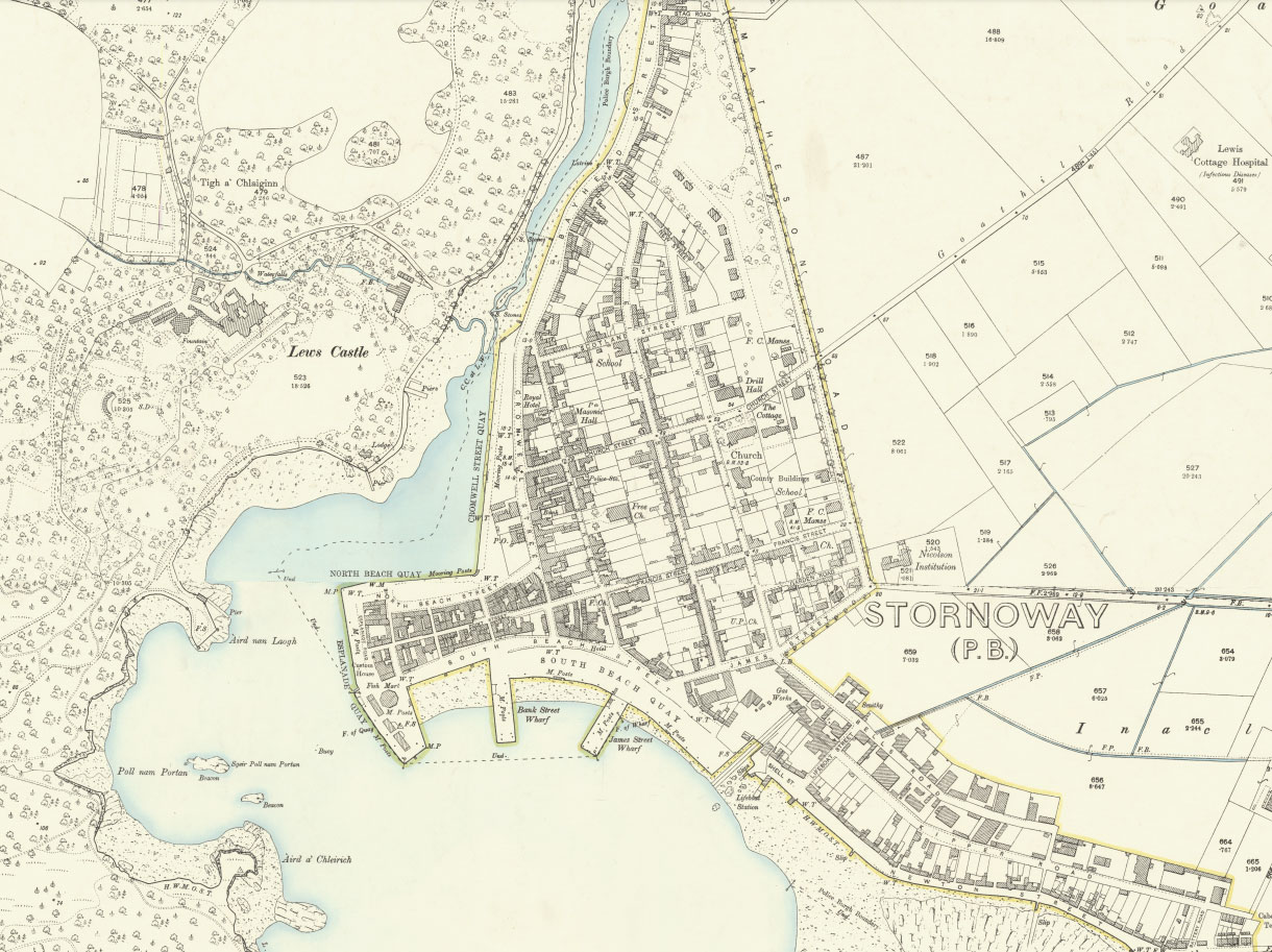
Ordnance Survey 25 inch to the mile, 1895-97

The Ordnance Survey 25 inch to the mile (or 1:2,500) County Series forms the most detailed topographic mapping for all the inhabited regions of Scotland from the 1890s to the 1940s. The maps are immensely valuable for local history, allowing practically every feature in the landscape to be shown. They provide good detail of all buildings, streets, railways, industrial premises, parkland, farms, woodland, and rivers. Their bold and clear style allows easy interpretation for a wide range of uses.

By this time, the harbour and its fisheries were particularly active, as reported in 1882:

"Stornoway is also the centre of the greatest of the Scottish fishery districts, embracing the whole of the Outer Hebrides. In 1883 the district contained 203 first-class boats, 419 second-class boats, and 476 third-class boats, finding employment for 4185 fisher men and boys and 3628 other persons. The value of the boats was £34, 401, of the nets £25,742, and of the lines £9208. In the same year 1117 boats fished in the district, and employed 6387 men and boys and 2895 other persons, while there were 68,163 barrels of herrings cured. About half the number of barrels exported go to St Petersburg, about a fourth to Stettin, and the rest to Danzig and Hamburg. In the same year the number of cod, ling, and hake cured was 444,490, while the value of the different kinds of fish sold fresh was over £34,000. There is a small boatbuilding yard, rope and sail works, a distillery, and a chemical work, which is, like that at Garrabost, intended for the manufacture of paraffin and lubricating oils from peat; and there are the usual local industries."

F.H. Groome, Ordnance Gazetteer of Scotland (1882-4)

  • Name: Ordnance Survey
  • Title: A georeferenced layer of County Series 25 inch to the mile mapping
  • Date: Revised: 1895-97
  • Description: Each map ; 64.4 x 96.6 cm.
  • Courtesy of the National Library of Scotland

1919 - Stornoway

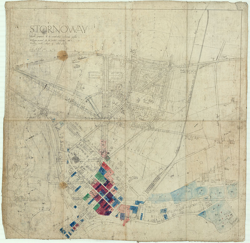
Port Sunlight plan of Stornoway, showing proposed lay-out, 1919

From May 1918 the island of Lewis was purchased by the successful industrialist and soap magnate William Lever, 1st Viscount Leverhulme. Leverhulme’s main priority was the revival of the fishing industry through capital investment, better transport and marketing, following his acquisition of the Mac Fisheries chain of fishmongers. However, he was also very interested in town planning, and he had previously developed the model village of Port Sunlight, near Birkenhead, constructed from 1888.

This town plan of Stornoway is by James Lomax-Simpson, Leverhulme’s godson and also his chief architect at Port Sunlight. Simpson took charge of the Architectural Department of Lever Brothers from 1910 and he was made a director in 1917. In his role as Company Architect, he worked in over twenty-five different countries around the World, but he also carried out much work for Lever himself, including alterations and additions to Lews Castle. The plan also illustrates part of Leverhulme’s ambitious ideas for redeveloping Stornoway along garden city lines, with new suburbs, broad avenues, circuses, and open spaces. The new planned railways, that were part of the wider plans for the economic transformation of Lewis, curve in and down to the Harbour on the eastern side of the town. Existing roads are shown with dashed lines. In places, ‘Parlour Cottages’ were planned, which had been constructed at Port Sunlight, as larger 'Arts and Crafts' residences for working families with a parlour at ground-floor level. Although visionary and ambitious, some of the new planned streets would have demolished much of the original old town. Over time, the plans were subsequently altered, shown as annotations on top of the original plan. Some construction began along these lines in the 1920s, but economic difficulties and considerable opposition to Leverhulme’s plans by the islanders curtailed developments, and the schemes were largely abandoned by 1923.

  • Name: Simpson, J.L.
  • Title: Port Sunlight plan of Stornoway, showing proposed lay-out. By J.L. Simpson architect. 16/07/1919
  • Date: 1919
  • Description: 1 map: col.; 71 x 71 cm
  • Courtesy of The Stornoway Trust

1950s? - Stornoway

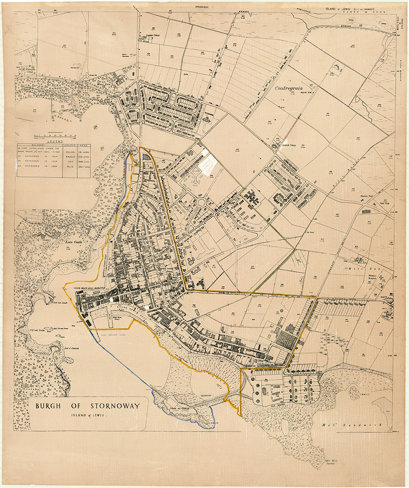
Burgh of Stornoway;  Plan of changes 1904, 1954; early 20thC

This plan’s main purpose is to show the extension of Stornoway Burgh’s administrative boundaries from 1862 through to 1954, and it was probably drawn soon after 1954. As the legend to the upper left makes clear, the coloured lines show the boundaries at four points in time with the size of the burgh:

  • the original boundaries of the town under the Police Burgh Act 1862/1863 (in yellow) - 151 acres
  • as extended in 1904 (in brown) - 255 acres
  • as extended in 1935 (in red) - 545 acres
  • as extended in 1954 (in blue) - 596.7 acres

The colour has faded, and although the yellow and blue boundaries are still clear, the brown and red boundaries are harder to see to the upper right, extending the town boundaries inland.

As well as showing boundaries, the map is particularly useful in giving a topographic update of Stornoway through to the mid-1950s. The map uses the Ordnance Survey 25 inch to the mile maps of 1895 (see above) as its base, and the field parcel numbers and acreages match the original 1890s sheets. But updates to the 1950s have been drawn on, including new streets, buildings, industrial premises, wharves, and related infrastructure. The map bears useful comparison with the Ordnance Survey’s 1:2,500 mapping of 1964 (see below), allowing features constructed in the intervening decade to be seen. The 1950s map shows planned buildings and streets that were built; on the 1950s plan, the outlines of some streets and buildings, presumably planned or under construction, are shown, and the completion of these can be seen on the 1960s Ordnance Survey mapping. This useful and interesting map was probably commissioned by the Town Council for planning purposes.

  • Title: Burgh of Stornoway; Plan of changes 1904, 1954; early 20th C
  • Date: 1950s?
  • Description: 1 map: col.; 92 x 111 cm.
  • Courtesy of Stornoway Public Library


1964 - Stornoway

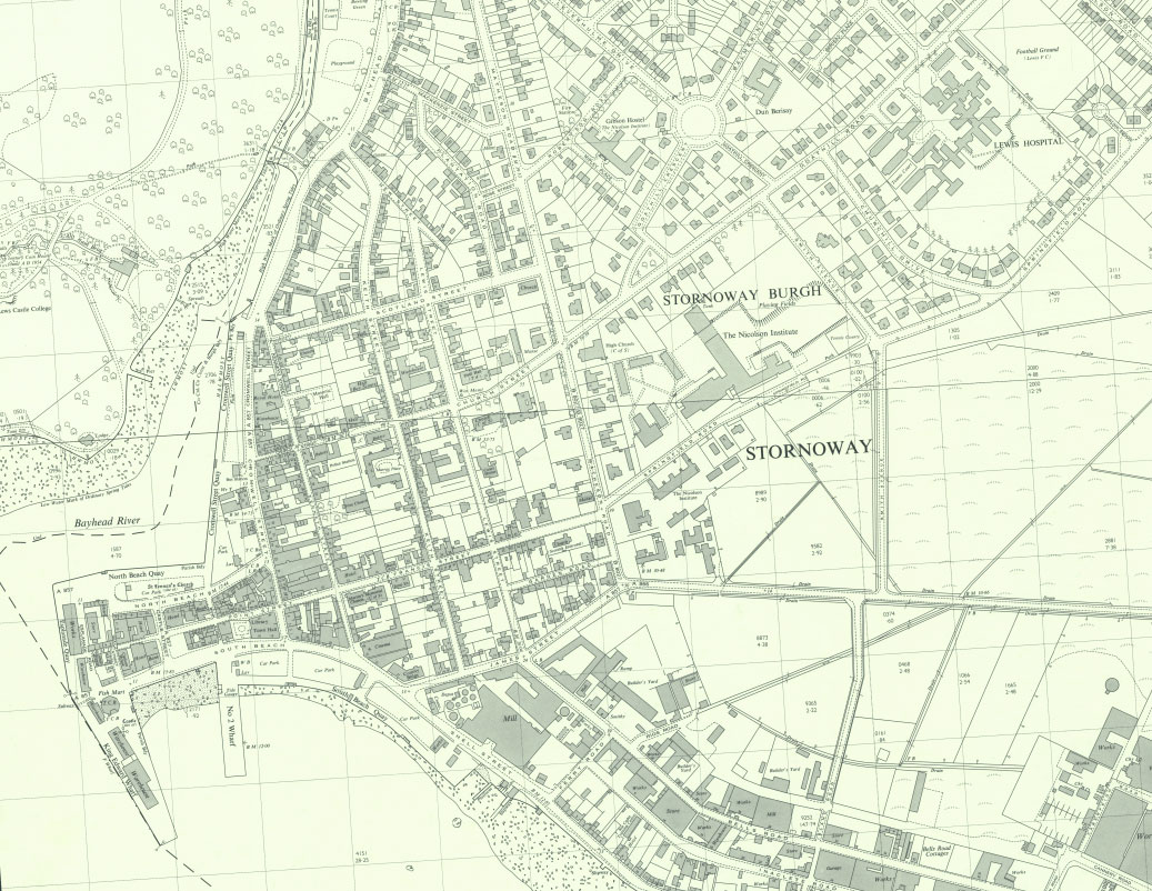
Ordnance Survey National Grid mapping, 1964

This series is a continuation of the Ordnance Survey 25 inch to the mile County Series (see above), but with sheetlines now based on the National Grid. This is the next detailed Ordnance Survey mapping of Stornoway after the 2nd edition mapping of the 1890s, and the latest edition that is out-of-copyright. The map series is a standard topographical authority showing practically all significant man-made and natural features to scale (i.e. without generalisation and reduction of detail). All permanent objects covering 16 square metres as well as most detached features covering 2 square metres are shown. The maps also show the divisions between houses, and they distinguish and name public and industrial buildings. This is the first standard Ordnance Survey series to also show house numbers, and more generally, all streets and detached farms and features are named. Land use is clearly shown with symbols distinguishing rough ground from arable, with different types of trees distinguished. Parkland, paths, field numbers and acreages are all shown. Sand, mud and rocks are also clearly distinguished around the coast. The maps also record spot heights in metres, and all administrative urban and rural boundaries.

  • Name: Ordnance Survey
  • Title: A georeferenced layer of National Grid 1:2,500 scale mapping
  • Date: Surveyed: 1964
  • Description: Each map ; 40 x 80 cm.
  • Courtesy of the National Library of Scotland


Change transparency of map overlay: